NHPRC Support

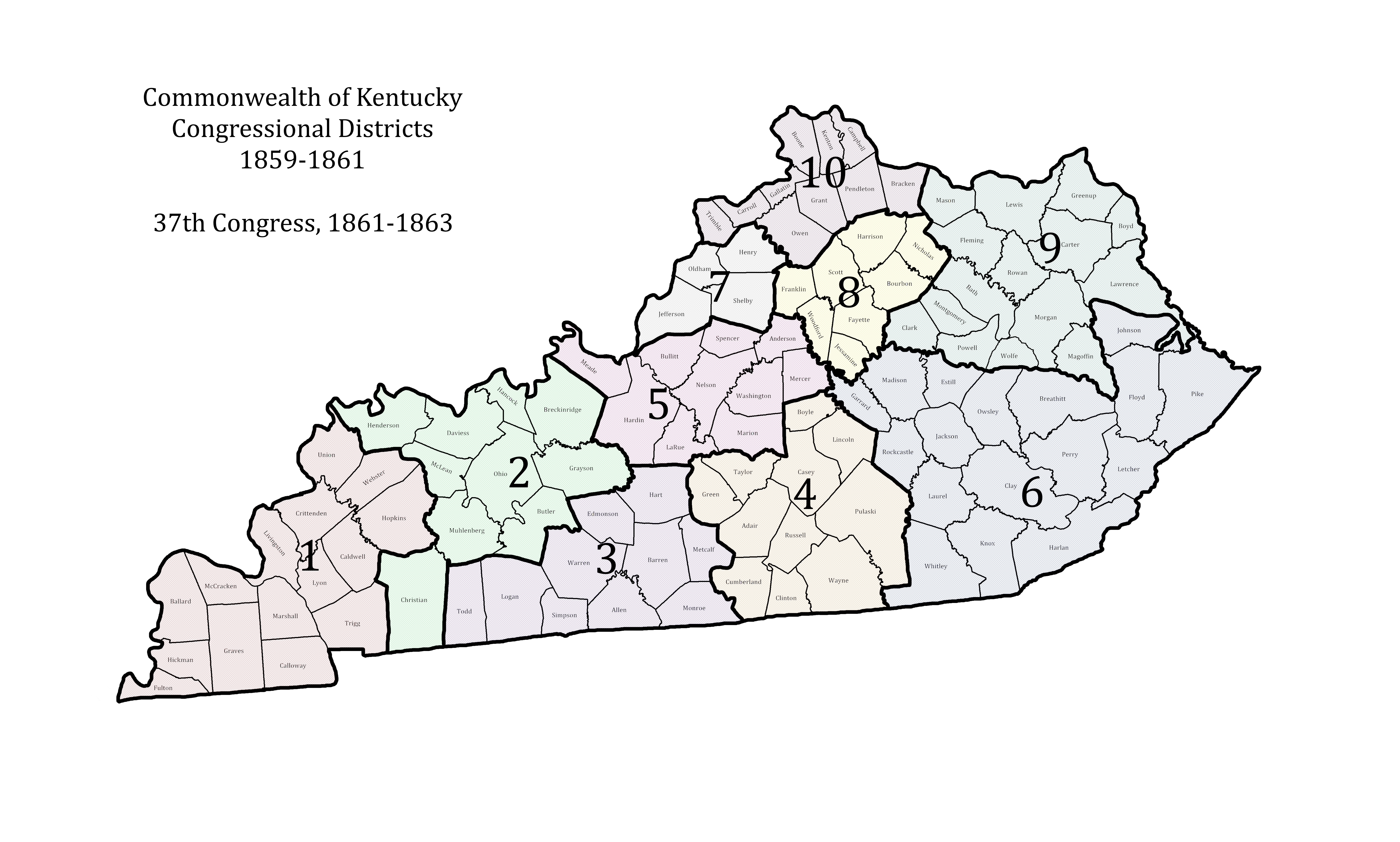
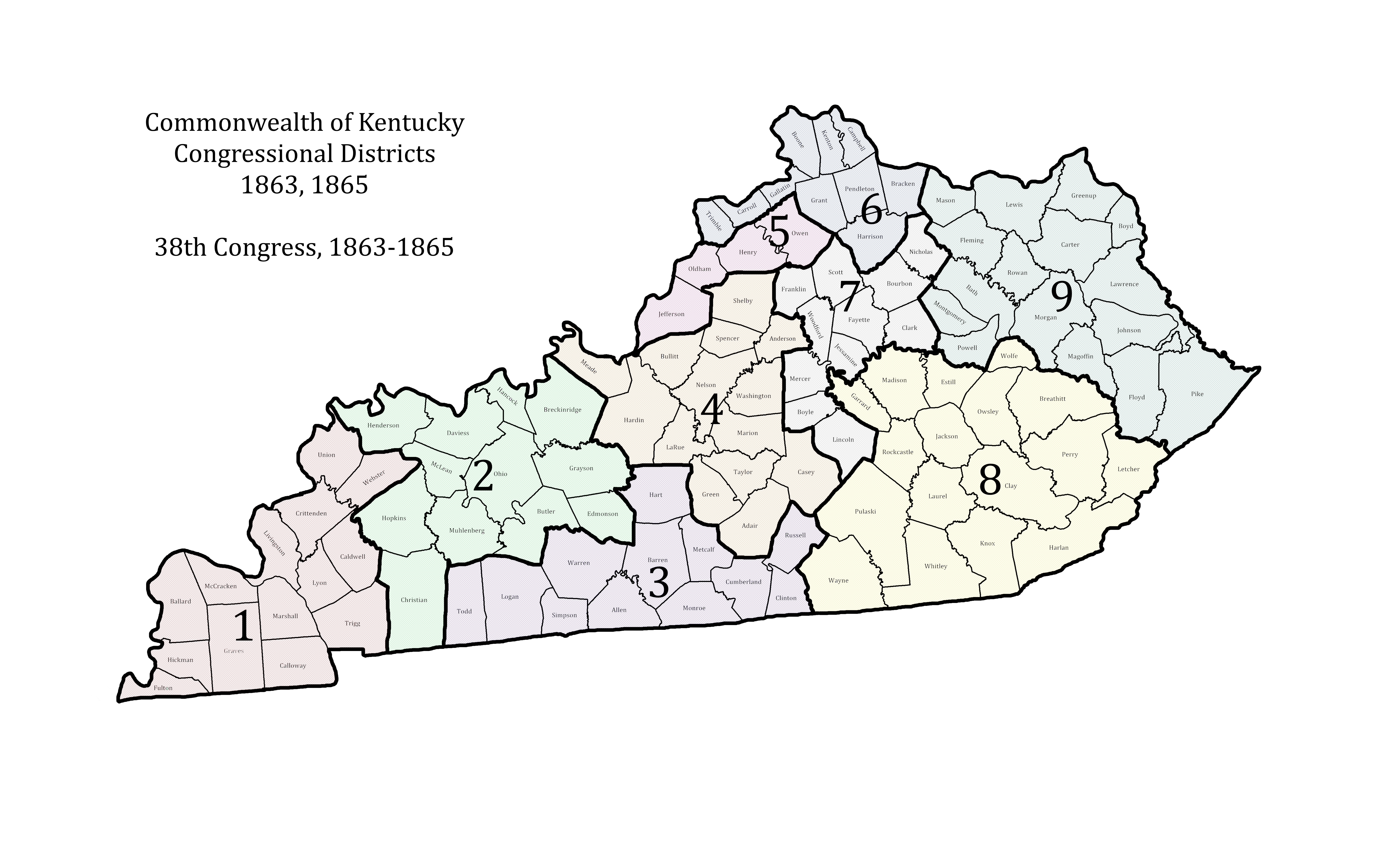
The Civil War Governors of Kentucky Digital Documentary Edition and the Kentucky Historical Society are proud to announce that Civil War Governors was awarded $62,400 in the May 2016 cycle of National Historical Publications & Records Commission (NHPRC) funding.

This is the second grant Civil War Governors has recieved from NHPRC. The first grant supported the digital publication of Early Access, an Omeka interface that will host 10,000 Civil War-era documents. This site will allow users to access 10,000 digital document images and transcriptions, and sample the rich content that Civil War Governors will deliver. Civil War Governors true impact on scholarship, however, will be in annotation. To the extent possible given the restrictions and biases of the historical record, Civil War Governors will identify, research, and link together every person, place, and organization found in its documents. This web of tens—perhaps hundreds—of thousands of networked nodes will dramatically expand the number of actors in Kentucky and U.S. history, show scholars new patterns and hidden relationships, and recognize the humanity and agency of historically marginalized people. The network of identified and annotated people, places, businesses, government agencies, and military units, will come as close as possible to a historical reconstruction of mid-nineteenth century society as it was lived and experienced in wartime Kentucky.

This second grant will support that next phase of work: publishing an annotation interface of 1,500 fully edited and linked documents. This important step to the full Digital Documentary Edition of a projected 40,000 documents will help reconstruct the lost lives and voices of tens of thousands of Kentuckians who interacted with the office of the governor during the war years. The diverse and largely unknown lives of the people captured in the Civil War Governors documents—generals and politicians, prostitutes and plantation mistresses, free African American professionals and “contraband” refugees—as well as the social, economic, political, and geographic networks they allow us to visualize and understand, are what Civil War Governors hopes to capture and deliver to the public.

This will be an important test of the Civil War Governors vision of a digital research environment within which a user can encounter the past multi-dimensionally through the documents and the powerful annotation network that links the documents together. In this document-driven historical ecosystem, users can explore intuitively—moving seamlessly through seemingly disparate historical themes, events, and topics; breaking into the plane of social and geographic space to understand the deep patterns that underlay the issues raised in a text or set of texts. Through it, Civil War Governors will understand how project staff must balance all phases of editing work as well as how a variety of users will navigate the research platform. Early Access shows the public a tantalizing sample of Civil War Governors content, but the next phase will demonstrate how Civil War Governors will shape the ways researchers, students, and teachers will explore the past in the future.

Visualizing Unionism: Congressional Redistricting in 1861

Modern political observers will not be surprised to hear that the redrawing of Congressional districts every ten years is an intense political battle within each state. Imagine how fraught that struggle was in Kentucky when the lines of political opposition were not only drawn between parties, but between opposing forces of loyalty and treason.

As CWG-K builds its 10,000-document Early Access interface (with funding from the NHPRC), we created a set of maps for the reference section of the site. Starting with blank NHGIS shape files based on the 1860 Kentucky census — files graciously processed by digital cartographer, GIS expert, and former KHS Research Fellow, Andrew W. Fialka — we tagged each district with a color code to track both geographic shifts (in the size of districts) and their physical placement within the state itself. This allowed us to fully visualize the redistricting process in the wake of the 1860 census and understand just how seriously the state government of Kentucky took the threat that the rebellion posed.

In the prewar map drawn from the 1850 census, Kentucky had ten congressional districts, varying widely in geographic size but (as required by law) roughly equal in population. Congressional Districts, 1859 to 1861, 37th Congress

Lincoln’s Secretary of the Interior, Caleb Smith, informed Governor Magoffin that Kentucky would lose a seat in the Thirty-Eighth Congress on July 9, 1861 (CWG-K document KYR-0001-023-0070), in the midst of one of the most politicized summers in Kentucky history. Elections for members of Congress and a new legislature served as referenda on secession in the state, which was in its period of official, declared neutrality. Union candidates dominated the summer voting, though some Confederate sympathizers soured on voting in the contests and stayed home. Nine of the ten Congressional seats went to Unionists, the exception being Southern Rights firebrand Henry C. Burnett of the far-west First District.

Legislative elections in August were equally lopsided Union victories, which meant that the new maps would be drawn by men determined to counter the rebel political threat. Looking at the 37th and 38th Congressional maps side by side, we can see how Unionist legislators sought to break up known clusters of rebel support and tip the balance in each Congressional district towards Union support.

Congressional Districts, 1863 to 1865, 38th Congress

The First District, rebel virtually to the core, lost Hopkins County, which may not have changed its electoral chemistry significantly. Hopkins was the scene of a protracted local political and paramilitary struggle between Union and Confederate elements in the later years of the war, but so was virtually every county in the region.

The Second District, anchored by Unionist Christian and McLean counties needed all of that loyal influence to brace divided Henderson and Daviess and stem electoral charges from the rebel counties in the eastern half of the district.

Any rebel sentiment in the Third District, the site of Kentucky’s secession convention at Russellville (Logan County) and the capital of the Provisional Confederate Government at Bowling Green (Warren County), was cunningly neutralized by stretching the district eastward to grab the hilly Union bastions of Cumberland, Clinton, and Russell counties.

What had been the Fifth District in the old system became the new Fourth and grew dramatically south and east in much the same manner as the Third. Notice how the soon-to-be guerrilla infested counties of Meade, Bullitt, Spencer, and Marion were neutralized with staunchly loyal Green, Adair (home of 1863-67 Governor Thomas E. Bramlette), and Casey.

The old Seventh, new Fifth, remained dominated by Louisville, a city that sent a fair number of citizens into the rebel ranks but was politically dominated by Unionists of the severest (sometimes even abolitionist/anti-slavery) stripe. Watch, though, as the new Fifth District swings east to break up the northern Kentucky rebel hive that was Owen and Grant counties. The rebels of Sweet Owen get drowned out by the Louisville vote.

Owen County’s old home, the Tenth District, became the new Sixth. And with the Owen-Grant connection broken up, the legislators thought it safe to reach down and include evenly divided Harrison County in the Northern Kentucky district, to be outweighed by the loyal voters in Covington and Newport.

Henry Clay’s old Ashland District, the heart of the Bluegrass, had fallen suspect in the eyes of the loyal legislators. The scions of the thoroughbred families were lured by the promise of John Hunt Morgan even as their old-Whig fathers drew maps in Frankfort. To brace the new Seventh District, the legislators dipped way down south into the Presbyterian-Unionist domain of Danville to prop up the district which John C. Breckinridge had represented more recently than Clay.

The two great mountain districts were largely safe from rebeldom. The new Eighth District, its political  center at London (Laurel County), remained loyal throughout the war and would become the rural base of the postwar Republican Party in the state into the twentieth century.

The new Ninth gained the rebel votes in Pike and Johnson counties, to be balanced by the unconditional unionists in Boyd and Greenup.

Reading the maps side by side gives us great insight into the ways that Kentucky leaders perceived the geography of rebellion — perceptions which have largely been borne out by historical scholarship since. What else do you see happening in these maps?

Patrick A. Lewis is Project Director of the Civil War Governors of Kentucky Digital Documentary Edition.